South Birmingham
Note that you
can click on any old picture to see a larger version
Dogpool Lane Bridge
|
|
 |
 |
| 28/2/1954 |
3/4/2006 |
| I
thought it would be interesting to include these two pictures as the
changes over 50 years are minimal - but not for long! The modern
view shows a 17T limit on the old bridge and there has long been a plan
to replace it. 2012 is a likely date for this to happen. I
guess time will tell... |
|
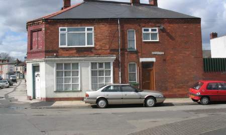
NX359 Fashoda Road
|
|
 |
 |
| 23/8/1954 | 3/4/2006 |
| It's
hard to believe that steam road rollers were still being used in the
1950's but my father's photograph proves it. On the corner of Fashoda Road was Allen's, purveyors of Barbers Teas. I was surprise to find a much faded 'Allen's' sign just visible on the much altered shop building when I visited in 2006. |
|
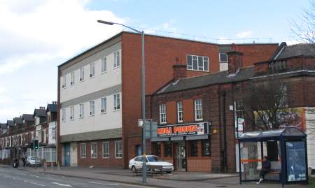
GPO Building, Dogpool
|
|
 |
 |
| 29/5/1955 |
3/4/2006 |
| In 1955,
a modern addition to the Selly Park section of Pershore Road was taking
shape - a new telephone exhange for the GPO (General Post Office for
those too young to remember!). It's still there today but largely
empty and unused as modern electronics have replaced the clumsy and
noisy Strowger switches of the past. |
|
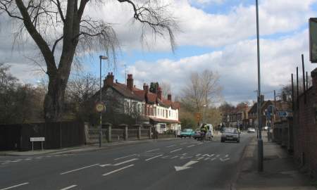
Dogpool |
|
 |
 |
| 27/3/1961 |
23/10/2005 |
| Why
isn't my modern view an accurate copy of my father's picture?
Because it was more intended to duplicate this
old post card. Comparing all three is interesting. The post card shows the Ten Acres Tavern on the corner of Pershore Road and St Stephens Road. This was replaced by the Dogpool Hotel, seen in both pictures above, and it is now known as the New Dogpool Hotel. On the corner of Dogpool Lane was the Dogpool Inn and the building was still there in 1961. The row of shops to the right have remained in place, though much changed over the years. |
|
Edwards Stores, Stirchley
|
|
 |
 |
| July
1963 |
3/4/2006 |
| Edwards
Stores lay in the centre of Stirchley Village. My parents were
back in Birmingham and stocking up with goods after moving to Ledbury a
few weeks earlier. A view
of the interior shows my mother on the right hand side with my
brother, Keith, in his pram. |
|
Holly Rd, Cotteridge
|
|
 |
 |
| 8/2/1960 |
3/4/2006 |
| My
parents moved to Holly Road after getting married and my brother was
born in one of the houses on the left. I have to say that I much
prefer the consistency of the old days compared to how things look
today. |
|
Pershore Rd, Cotteridge
|
|
 |
 |
| 13/2/1962 |
3/4/2006 |
| The most
obvious difference between these two pictures is the loss of St Agnes's
church to the left of centre. However, note the missing first
floor bay windows on the three storey buildings on the right, a real
detrimental modification, in my humble opinion. |
|
Friends Hall, Cotteridge
|
|
 |
 |
| 17/1/1963 |
3/4/2006 |
| Another
sad loss for Cotteridge, a village that otherwise maitains many nice
old buildings, is the attractive Friends Hall that was built on Watford
Road in 1901. In my father's picture of 1963, the site is up for
sale for the construction of shops. There is still a Friends Hall
behind the modern shops. |
|
Jct Pershore Rd South, Wharf Rd
|
|
 |
 |
| 2/4/1964 |
6/4/2006 |
| The busy
five road interchange at Kings Norton. Clockwise from the scene
of both pictures are Pershore Road South, Wharf Road, Masshouse Lane,
Redditch Road and The Green. Note how many cottages have been
lost on the approach to Redditch Road. Also lost here was the
characterful newsagent that was originally built as a chapel. |
|
The Bell, Northfield |
|
 |
 |
| 14/10/1962 |
3/4/2006 |
| I
remember The Bell at Northfield, but not the one in my father's
picture. It's modern replacement had a bad reputation and it was
replaced by the shops seen in the photo from 2006. Note how the
little tower on the shops reflects a feature seen on the left of the
original pub. The shop on the corner of Bell Lane was Huin's, a much loved shoe shop. |
|
Bridge, West Heath Rd
|
|
 |
 |
| 9/5/1962 |
3/4/2006 |
| The old
bridge over the River Rea on West Heath Road was too narrow for modern
times so had to be replaced. |
|
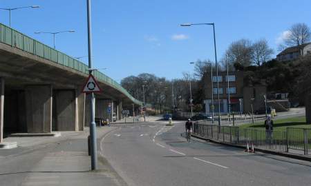
Rubery Village
|
|
 |
 |
| 3/5/1962 |
5/4/2006 |
| Rubery
itself was (and mostly still is) part of Worcestershire and not part of
Birmingham. This picture, and the one below, show the
border. Where the grassy central reservation ends, the rear of a
sign can be seen and that sign says, "City of Birmingham". The proof that these pictures really are of the same location can be seen in the shop building visible under the flyover on the left hand side of the picture from 2006. |
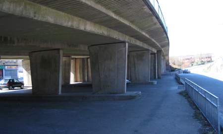
|
Rubery Terminus
|
|
 |
 |
| 3/5/1962 |
5/4/2006 |
| Now
looking the other way towards the scene of the picture above, we can
see the major changes that took place to accomodate the A38 flyover. The boarded up shop, ready for demolition in 1962, had been owned by M.Slim. Why Rubery Terminus? Well, up until 1952, this had been the site of a tram terminus as seen in this picture. For some colour pictures of this location in the early 1960's, click here. |
|
 |
 |