Birmingham In Colour 1950's
It was a real surprise to find that we had boxes of full colour slides
as well as all the prints. There aren't a huge amount of
Birmingham, but what we have is a good selection from around the city,
especially in the southern half. This page features pictures
taken in the 1950's.
Old colour pictures really make an impact on me. With black and
white it's easy differentiate between the past and the present. A
fifty year old colour picture starts to blur the distinction...
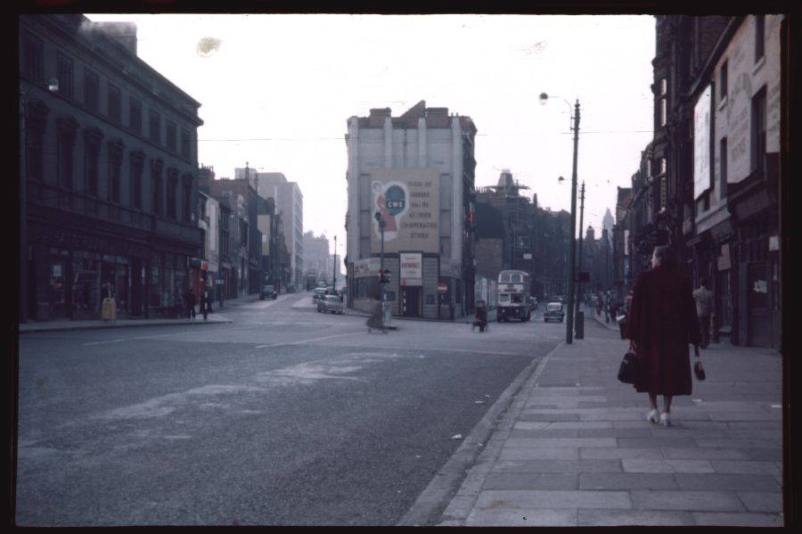
Horsefair Nr Holloway Head - 13/8/55
|
|
|
A rare D J Norton photo showing
Birmingham before the redevelopment started. This shot is taken
from Horsefair. The road to the left is Suffolk Street while the
road to the right is John Bright Street. The building on the
corner of the two has a sign saying, "Newnes". Thanks to John for
letting me know that Newnes were publishers. In fact, Newnes
still publish electronics text books today.
|
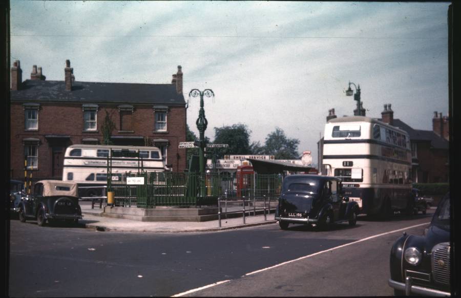
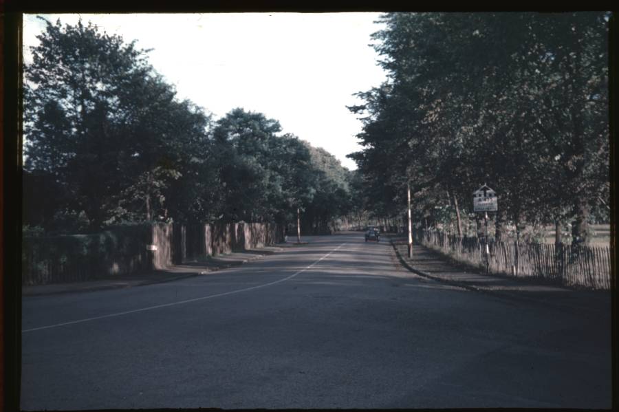
Selly Oak Village - 30/6/57
|
|
|
After some
initial confusion about the location for this shot, I've been persuaded
(thanks to Mike and Stephen) that it is the junction of Oak Tree
Lane with Bristol Road after all. The picture was taken from Oak
Tree Lane and is looking towards Bristol Road. The bus on
the left would most likely have been a 61, 62 or 63 heading towards the
city
centre although David pointed out that it could also have been a 21
about to turn into Harborne Lane. Pamela muddied the waters
further by suggesting that the 21 didn't turn into Harborne Lane at the
time - that would have been the 20a or 20b! The number 11
is waiting
to cross into Harborne
Lane. One thing that does confuse me is that the City Centre
signpost says 3 1/2 miles in 1955. Today it says 4
miles! Can anyone explain? Here
is a view of the scene today.
|
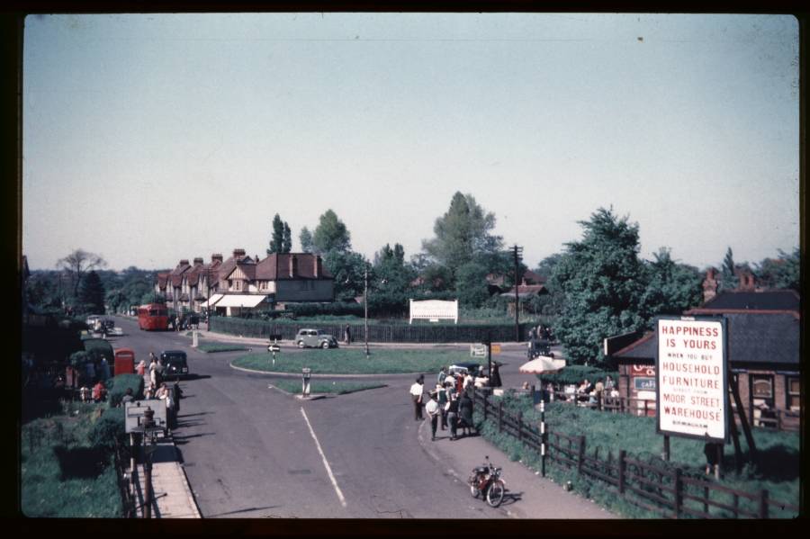
Marston Green from Signal Box - 30/5/55
|
|
|
A superb
picture of Marston Green taken from the signal box. My father's
friend, Vic Goodwin, was the signalman so I'm sure he had no trouble
reaching the vantage point for this shot.
I wondered why it was so busy, especially at the cafe to the right. I
thought it was because it was Late Spring Bank Holiday but that wasn't
introduced until 1971. Prior to that, Whit Monday could be any
date between 11 May and 14 June as it was 7 weeks after Easter
Monday. In 1955, Easter Monday was 11 April so the picture was
taken on Whit Monday, 1955!
I love the sign! It says, "Happiness is yours when you buy your
household furniture direct from Moor Street Warehouse
Birmingham". And I thought the consumer society was something
recent...
|
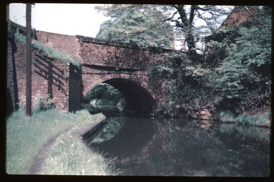
Canal Bridge Somerset Rd - 31/5/55
|
|
|
A lovely
shot of a tranquil scene in the popular Edgbaston area of the
city. The Worcester and Birmingham Canal heads towards the city
centre as it disappears under the bridge. To the far left, blue
bricks mark the site of a rail bridge carrying Somerset Road over what
was once the Birmingham West Suburban Railway.
|
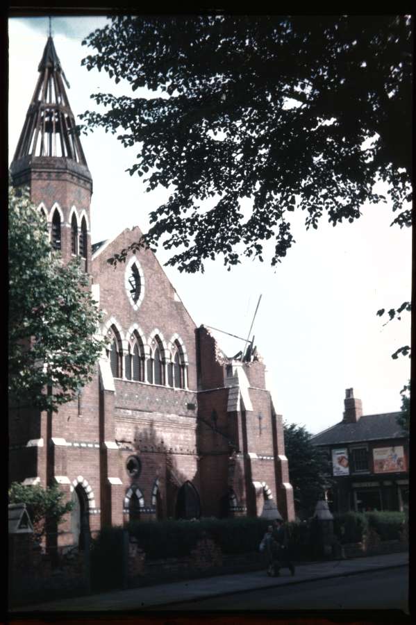
Church Runcorn Rd - 5/7/56
|
|
|
This shot
was taken from the western side of Moseley Road looking towards the
junction with Runcorn Road. The Congregational Church stood on
the corner of the two roads. I wondered if it was being demolished
or was the victim of a fire or even bomb damage in the war? Kieron
was kind enough to get in touch with the following information:-
"The site for this church was acquired in 1861. The committee responsible
for the new church obtained plans from the architect Mr. Edward Holmes,
following which they entered into a contract with Mr. Charles Jones to build
a church to seat 1,000 people at a cost of £2,200. The foundation stone was
laid by the Reverend. R. W. Dale in July 1861. The inaugural service took
place on Tuesday June 25th 1862 following by lunch in a tent! The total cost
came in at £3,700, including two vestries to the rear for ministers and deacons.
In May 1954 it was announced the Congregational Church was to be sold as it
had not been used for services for some time. However, it was stated that the
building was in good order.
This does not definitely answer your question why the turret was coming down -
it was possibly the start of demolition. It is clear from the above info that it was
not war damage. Certainly, by the time of a map dated 1965 a metal works
occupied the site."
In 1946, the shop visible on the right hand side was an ironmongers
called Sandbrook & Co. I can make out that the sign says,
"Oils", so perhaps it was still under the same ownership in 1957.
|
Houses Mary St - 2/9/55
|
|
|
Mary Street
in Balsall Heath. I had cause to drive down here when taking
pictures for the book and I was delighted to see those unusual
balconies still in place.
The popularity of smoking in the 1950's in made clear by all the signs
on the corner shop - Player's, Will's "Gold Flake" and "Three Castles"
and Capstan.
Victoria got in touch to say that the shop next to the corner shop was
run by a lady called Zelda. Then Maria was kind enough to provide
this amusing story about another resident of the street:
"There used to be an Egyptian Dr called Dr Dearey, he had a very
strange set up, what ever the ailment he always gave you an injection,
my father like most of his patients would tip him and he took it.
The larger the amount the better consultant you got to see if you
needed to be reffered to the hospital for anything.
I always remember he had a skull on his desk with a cigarette hanging
from his mouth and a plaque which read Poor old Fred died in bed.
I kid you not, it was quite a scary thing for a child to look at.
I'm sure he died in the 70s and his son took over the surgery.
Not sure if he is still running it now though"
|
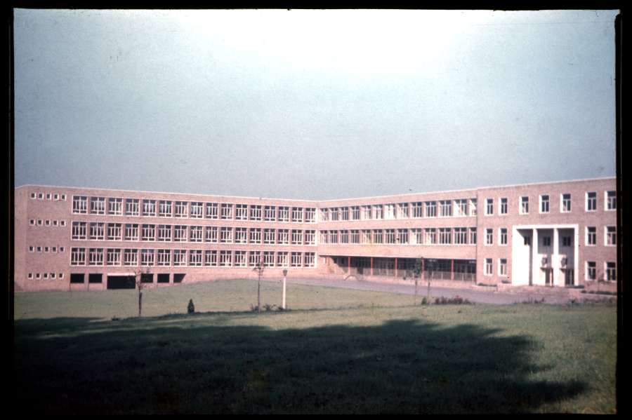
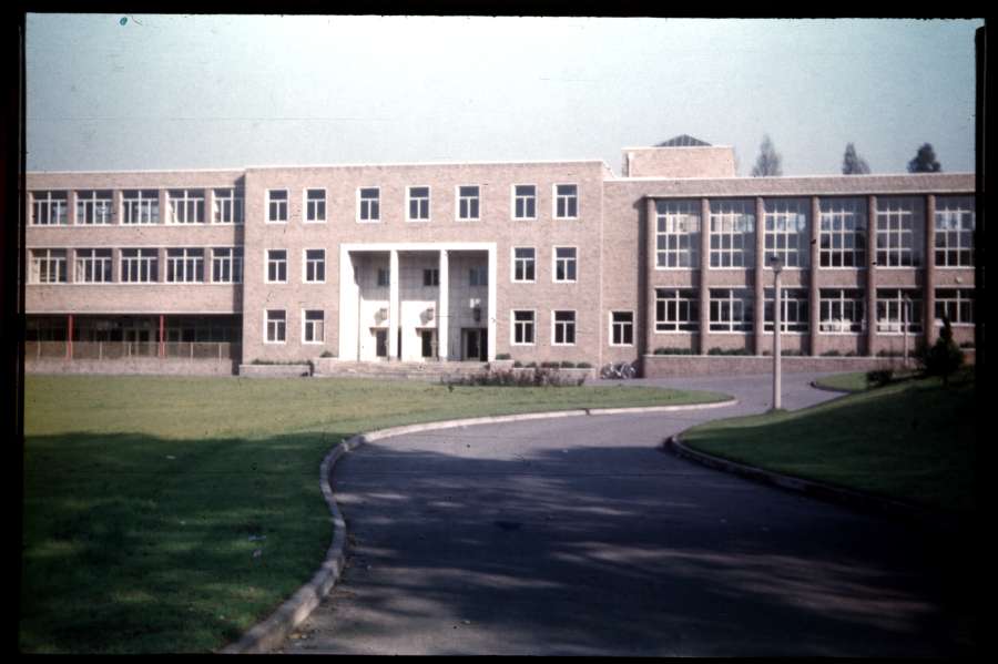
Queensbridge School - 13/10/56
|
|
|
Two pictures
of what appears to be the then brand new Queensbridge School in
Moseley. It must have been a real revelation to pupils and staff
used to Victorian schools! It's still in business today - 50
years later. Here
is its website.
|
Moor Green Lane (Queensbridge Rd) - 2/9/55
|
|
|
This picture
of Moor Green Lane was taken from close to the junction with Russell
Road and Reddings Road. The solitary car is located where the
road becomes Queensbridge Road. The signpost says, "A435 Alcester
Kings Heath".
The open land to the right was where Britannic Assurance would relocate
to when their splendid
city centre premises were demolished during the construction of the
inner ring road.
|
Moor Green Lane - 28/10/55
|
|
|
Moor Green
Lane again, this time close to Shutlock Lane. To the right is
Highbury Park, close to Highbury Hall,
the one time home of Joseph
Chamberlain - an important polical figure in Birmingham's history.
This scene is little changed today. Obviously the gas lamp post
is no longer there! The other main difference is that the road is
now a curious little dual carriageway at this location.
|
Dogpool - 11/9/55
|
|
|
You would
find it difficult to take a picture like this today as this junction is
very busy! It's hard to believe there is only one car in this
shot...
Taken from St. Stephens Road, Pershore Road is off to the left while
Dogpool Lane heads off to the right. It's clear that this picture
was taken to record the construction of the GPO telephone exchange at
Selly Park.
|
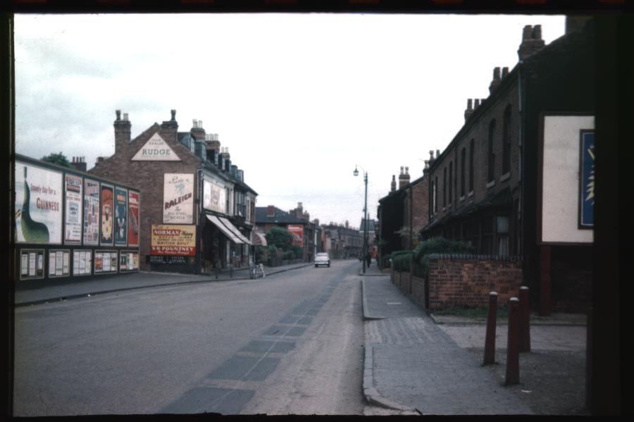
Pershore Rd Nr Pavilion - 3/6/56
|
|
|
Just a
stone's throw from the scene above, this shot shows a view from the
northern end of Stirchley looking towards Selly Park. The narrow
section of Pershore Road cuts through an area known as Ten Acres.
This was the home of Cox, Wilcox & Co. Ltd and I was delighted when
a housing development in the area retained the frontage
of the works building.
The yellow and red sign on the bicycle shop says, "Ride a Norman Nippy
Moped - British Built". Underneath, S.R.Pountney offers a way to
finance the purchase, "Hire Purchase Arranged".
The Pavilion referenced in the title of this picture was a cinema and
was to the right of where my father was standing. Today it's a
gym and bowling alley.
|
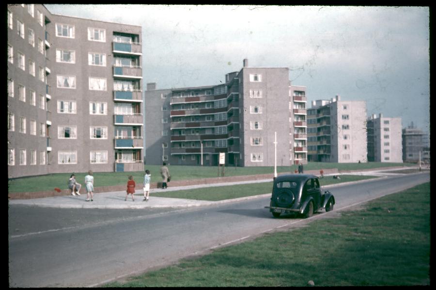
Flats Holly Bank Rd from N - 22/5/55
|
|
|
At the time
the picture was taken, these flats must have been the height of
modernity. The old car in the foreground provides the only
indication that this picture is over 50 years old.
I didn't know where Holly Bank Road was until I looked it up in the A
to Z. I discovered that it was only a small diversion en route to
a friends house so I drove down the road and found that the flats
were still there. The chimneys on this modern view give away
the age of the flats, I think.
|